Back Kiel-kanaal Afrikaans قناة كيل Arabic قناة كيل ARZ Canal de Kiel AST Kil kanalı Azerbaijani Кільскі канал Byelorussian Кільскі канал BE-X-OLD Килски канал Bulgarian कील नहर Bihari কিল খাল Bengali/Bangla
| Nord-Ostsee-Kanal | |
|---|---|
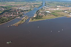
 Locks at Brunsbüttel connecting the canal to the River Elbe estuary, and thence to the North Sea | |
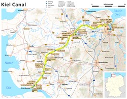
 Current map of Kiel Canal in Schleswig-Holstein | |
| Specifications | |
| Length | 98.26 km (61.06 miles) |
| Maximum boat length | 235 m (771 ft) |
| Maximum boat beam | 32.5 m (107 ft) |
| Maximum boat draft | 9.5 m (31 ft) |
| History | |
| Construction began | 1887 |
| Date completed | 1895 |
| Date extended | 1907–14 |
| Geography | |
| Start point | Brunsbüttel (North Sea) |
| End point | Kiel (Baltic Sea) |
The Kiel Canal (German: Nord-Ostsee-Kanal, literally "North [Sea]–East (i.e. Baltic) Sea canal", formerly known as the Kaiser-Wilhelm-Kanal) is a 98 km (61 mi) long freshwater canal in the German state of Schleswig-Holstein. The canal was finished in 1895, but later widened, and links the North Sea at Brunsbüttel to the Baltic Sea at Kiel-Holtenau. An average of 460 km (290 mi) is saved by using the Kiel Canal instead of going around the Jutland Peninsula. This not only saves time but also avoids storm-prone seas and having to pass through the Danish straits.
The Kiel Canal is one of the world's most frequented artificial waterways with an annual average of 32,000 ships (90 daily), transporting approximately 100 million tonnes of goods.[1]
Besides its two sea entrances, the Kiel Canal is linked, at Oldenbüttel, to the navigable River Eider by the short Gieselau Canal.[2]
- ^ "Nord-Ostsee-Kanal" (in German). Wasserstraßen- und Schifffahrtsverwaltung des Bundes. Retrieved 2021-08-14.
- ^ Sheffield, Barry (1995). Inland Waterways of Germany. St Ives: Imray Laurie Norie & Wilson. ISBN 0-85288-283-1.
© MMXXIII Rich X Search. We shall prevail. All rights reserved. Rich X Search